Immersive 360° Visualizations of Roads and Other Infrastructure within ArcGIS
Local governments play a pivotal role in our communities, overseeing infrastructure, public services, and emergency response. In a rapidly advancing technological landscape, embracing innovative tools that enhance efficiency and service delivery is essential. This article explores the transformative potential of consumer-grade 360° cameras when integrated with ArcGIS in local government operations. We’ll delve into the impact of these cameras and introduce two user-friendly tools for seamless integration.
The Power of 360° Cameras
Consumer-grade 360° cameras are now more affordable and accessible than ever, ushering in significant benefts in local government operations:
- Efficiency and Cost Savings: These compact and cost-effective cameras provide instant panoramic insights without the complexities, high costs, or logistical challenges associated with UAVs or lidar systems.
- Enhanced Departmental Collaboration: The accessibility of 360° imagery and video within ArcGIS promotes collaboration across all departments, even for individuals with limited GIS experience.
- Streamlined Infrastructure Management: Quick and precise reporting of roadway and infrastructure conditions becomes feasible through 360° imagery and video. Whether employed with custom-built systems or ESRI’s deployable solutions, managing infrastructure and assets becomes more straightforward.
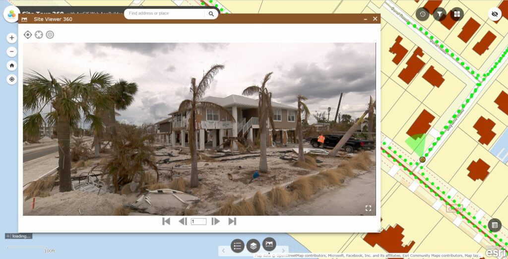
- Effective Emergency Response: During emergencies, 360° cameras enable the rapid capture of conditions for swift responsiveness. They provide an immersive view of affected areas, facilitating fast and accurate assessments without the challenges posed by traditional methods such as UAVs and lidar.
- Engaging Virtual Tours: These immersive, wide-area virtual tours offer interactive experiences for agencies and the community alike. They can highlight prominent projects and development efforts, such as parks, trails, and blight remediation.
- Community Engagement: Local governments can create interactive platforms for community interaction within a geospatially accurate virtual environment. This enhances engagement by sharing project information in an engaging and informative manner.
- Progress Monitoring and Collaboration: On-site visualizations aid in project oversight and progress monitoring, particularly in construction management and logistics. Organizing 360° imagery by location and time allows for easy verification of completed work.
- Tender Competition and Proposals: Access to detailed geospatial information empowers contractors to submit accurate and well-supported proposals. They can analyze drainage options, road slopes, traffic conditions, and accessibility, leading to more competitive and informed bids.
Empowering Non-GIS Professionals
A groundbreaking aspect of this innovation is its accessibility to individuals with minimal or no GIS experience. Workflows can be designed to be straightforward and visualization-centric, enabling all departments to utilize them easily. This democratization of geospatial tools ultimately enhances project delivery, reduces costs, and elevates service delivery to citizens.
360° Imagery & Video Tools
To fully harness the potential of 360° imagery and video within ArcGIS workflows, consider these two user-friendly tools:
- Site Viewer 360 for ArcGIS: This tool seamlessly integrates 360° imagery and video into ArcGIS workflows, enhancing visualization and collaboration.
- GeoTube for ArcGIS: GeoTube simplifies the process of integrating 360° imagery and video into ArcGIS, making it accessible to professionals with varying levels of GIS experience.
Nodeology, the developer of these tools, specializes in delivering geospatial 360° imagery solutions that drive operational efficiencies. Committed to developing user-friendly tools and promoting the adoption of operational efficiencies, they understand the significance of ArcGIS solutions for local governments, emergency management, and AEC firms.
Conclusion
Consumer-grade 360° cameras have the potential to revolutionize local government operations. They enable better community engagement, improved infrastructure management, enhanced emergency response capabilities, and streamlined collaboration among departments. By embracing user-friendly tools like Site Viewer 360 and GeoTube, local governments can harness the power of 360° imagery and video to deliver more efficient and effective services to their communities.