Empowering Non-GIS Professionals with Highly Customizable Workflows
Simplicity and a focus on visualization make it easy to create uncomplicated workflows, enabling individuals—regardless of their GIS expertise—to work efficiently.
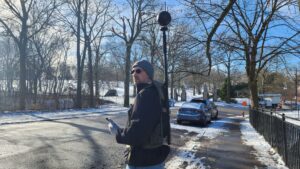
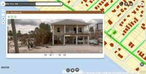
Emergency Response: 700 Miles of Ultra High-Resolution 360° Imagery
SiteTour360.com swiftly captured an expansive 700-mile area in the aftermath of Hurricane Ian using a Mosaic 360 camera, renowned for its capability to consistently produce top-notch imagery even in challenging environmental conditions. This remarkable device operated continuously for 8 hours, producing a stable stream of high-quality 360° visuals.
Everything you need to know about setting up a 360° program
From your 360° camera to workflows that streamline operations.