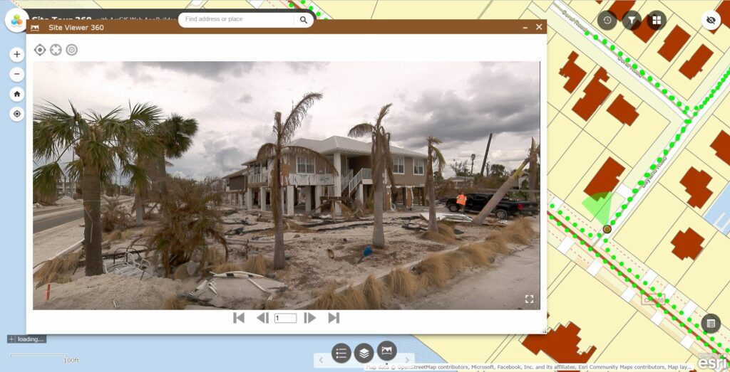
An innovative 360° imagery tool seamlessly integrates with ArcGIS Online, providing Emergency Management professionals with a comprehensive solution for visualizing and analyzing disaster areas. By leveraging ultra-high-resolution imagery captured after Hurricane Ian, teams can assess damage, identify hazards, and take proactive measures to mitigate risks.
𝐄𝐧𝐡𝐚𝐧𝐜𝐢𝐧𝐠 𝐄𝐦𝐞𝐫𝐠𝐞𝐧𝐜𝐲 𝐑𝐞𝐬𝐩𝐨𝐧𝐬𝐞 𝐰𝐢𝐭𝐡 𝟑𝟔𝟎 𝐈𝐦𝐚𝐠𝐞𝐫𝐲:
Site Tour 360, following Hurricane Ian’s aftermath, captured an extensive 700-mile coverage of ultra high-resolution 360° imagery with a Mosaic 360 camera. Leveraging this imagery in ArcGIS, Emergency Managers gain a holistic view of the affected areas, enabling them to quickly assess the extent of damage and identify potential hazards that may not be immediately visible. Structural damage, gas leaks, or downed power lines can be detected, empowering teams to take proactive measures to address these hazards and prevent further damage or injury.
𝐄𝐟𝐟𝐢𝐜𝐢𝐞𝐧𝐭 𝐂𝐨𝐥𝐥𝐚𝐛𝐨𝐫𝐚𝐭𝐢𝐨𝐧 𝐚𝐧𝐝 𝐑𝐞𝐬𝐨𝐮𝐫𝐜𝐞 𝐀𝐥𝐥𝐨𝐜𝐚𝐭𝐢𝐨𝐧:
With a single person equipped with a 360° camera, entire project sites can be efficiently captured and shared, supporting the recovery efforts of Emergency Management teams. Through ArcGIS Online, teams can collaborate seamlessly, prioritize efforts, and allocate resources effectively, ensuring a streamlined response.
𝐓𝐫𝐚𝐜𝐤𝐢𝐧𝐠 𝐂𝐡𝐚𝐧𝐠𝐞𝐬 𝐎𝐯𝐞𝐫 𝐓𝐢𝐦𝐞:
Using our Site Viewer 360, you can easily track changes over time by navigating through different dates and observing the evolving situation. This feature enables Emergency Management personnel to make informed decisions, adapt strategies, and monitor progress during the recovery process.
𝐄𝐱𝐩𝐥𝐨𝐫𝐞 𝐭𝐡𝐞 𝐇𝐮𝐫𝐫𝐢𝐜𝐚𝐧𝐞 𝐈𝐚𝐧 𝐀𝐫𝐜𝐆𝐈𝐒 𝐎𝐧𝐥𝐢𝐧𝐞 𝐃𝐞𝐦𝐨:
Immerse yourself in the aftermath of Hurricane Ian with our interactive demo, showcasing the capabilities of 360 imagery for emergency response and recovery. Visit Hurricane Ian ArcGIS Online Demo to gain firsthand insights into the power of 360° imagery in ArcGIS Online.
𝐀𝐛𝐨𝐮𝐭 𝐒𝐢𝐭𝐞 𝐓𝐨𝐮𝐫 𝟑𝟔𝟎:
Site Tour 360 is an immersive media company in Gainesville, Florida, specializing in virtual tours, 360 photography, and 3D mapping. Learn more at www.sitetour360.com.
𝐀𝐛𝐨𝐮𝐭 𝐍𝐨𝐝𝐞𝐨𝐥𝐨𝐠𝐲:
Nodeology specializes in delivering geospatial 360 imagery solutions that drive operational efficiencies. We understand the importance of ArcGIS solutions for Emergency Management and are committed to developing user-friendly tools that enhance emergency response efforts. Learn more about Nodeology and our offerings at www.nodeology.net or reach out to us at info@nodeology.net.